![](/images/other/stat-length.png)
![Percorso A piedi Bad Schwalbach - Fischbach - Ramschied - Photo](https://media.geolcdn.com/t/1900/400/ext.pjpeg?maxdim=2&url=https%3A%2F%2Fmedia.geolcdn.com%2Ff%2F485da72c-27de-4567-a8d7-767a5e51addd.jpeg)
Fischbach - Ramschied
SityTrail - itinéraires balisés pédestres
Tous les sentiers balisés d’Europe PRO
![Lunghezza](/images/other/stat-length.png)
Lunghezza
11,1 km
![Altitudine massima](https://static1.geolcdn.com/siteimages/upload/files/1508320355ic_sort_altitude_max_24dp.png)
Altitudine massima
506 m
![Dislivello positivo](https://static1.geolcdn.com/siteimages/upload/files/1508320355ic_sort_den_pos_24dp.png)
Dislivello positivo
316 m
![Km-Effort](/images/other/stat-length.png)
Km-Effort
15,3 km
![Altitudine minima](https://static1.geolcdn.com/siteimages/upload/files/1508320355ic_sort_altitude_min_24dp.png)
Altitudine minima
340 m
![Dislivello negativo](https://static1.geolcdn.com/siteimages/upload/files/1508320355ic_sort_den_neg_24dp.png)
Dislivello negativo
322 m
![Boucle](https://static1.geolcdn.com/siteimages/upload/files/16400158638029165_repeat_loop_refresh_sync_direction_icon.png)
Boucle
No
Tag
Data di creazione :
2022-02-11 18:06:58.156
Ultima modifica :
2022-02-11 18:06:58.156
![A piedi](https://static1.geolcdn.com/sitytour/trail-icons/100.png)
3h28
Difficoltà : Facile
![Scannerizza questo codice QR per aprire il percorso nell'applicazione SityTrail](https://capi.geolives.com/qq0zvz2zws4bq2lad0pu/sitytour/trails/3099044/qr.png?size=200)
Applicazione GPS da escursionismo GRATUITA
Chi siamo
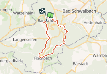
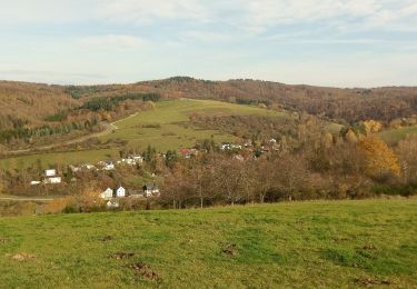
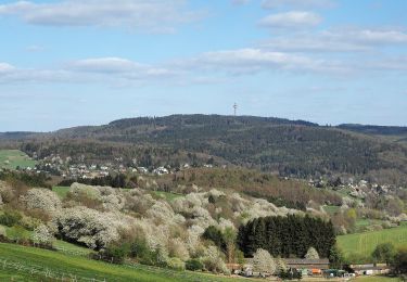
Percorso A piedi di 11,1 km da scoprire a Assia, Rheingau-Taunus-Kreis, Bad Schwalbach. Questo percorso è proposto da SityTrail - itinéraires balisés pédestres.
Descrizione
Symbol: weißes Schild: oben pinker Fisch, darunter pinker Text Ram-Fi
Localizzazione
Paese:
Germany
Regione :
Assia
Dipartimento/Provincia :
Rheingau-Taunus-Kreis
Comune :
Bad Schwalbach
Località :
Ramschied
Partenza:(Dec)
Partenza:(UTM)
430941 ; 5553923 (32U) N.
Commenti
Percorsi nelle vicinanze
![Percorso A piedi Bad Schwalbach - Schwälbchen's Flug - Photo](https://media.geolcdn.com/t/375/260/ext.jpg?maxdim=2&url=https%3A%2F%2Fmedia.geolcdn.com%2Ff%2Faf2a96e4-3837-4938-99ba-d57b1d943191.jpeg)
![A piedi A piedi](https://static1.geolcdn.com/sitytour/trail-icons/100.png)
Schwälbchen's Flug
A piedi
Facile
Bad Schwalbach,
Assia,
Rheingau-Taunus-Kreis,
Germany
![](/images/other/stat-length.png)
10,7 km | 14,4 km-effort
3h 16min
![](https://static1.geolcdn.com/siteimages/upload/files/16400158638029165_repeat_loop_refresh_sync_direction_icon.png)
Sì
![Percorso A piedi Bad Schwalbach - Nordic Walking Park 8 - Photo](https://media.geolcdn.com/t/375/260/ext.jpg?maxdim=2&url=https%3A%2F%2Fmedia.geolcdn.com%2Ff%2F64306b33-320a-4266-807e-3a311c77b146.jpeg)
![A piedi A piedi](https://static1.geolcdn.com/sitytour/trail-icons/100.png)
Nordic Walking Park 8
A piedi
Facile
Bad Schwalbach,
Assia,
Rheingau-Taunus-Kreis,
Germany
![](/images/other/stat-length.png)
9 km | 11,8 km-effort
2h 40min
![](https://static1.geolcdn.com/siteimages/upload/files/16400158638029165_repeat_loop_refresh_sync_direction_icon.png)
Sì
![Percorso A piedi Bad Schwalbach - Nordic Walking Park 7 - Photo](https://media.geolcdn.com/t/375/260/ext.jpg?maxdim=2&url=https%3A%2F%2Fmedia.geolcdn.com%2Ff%2F64306b33-320a-4266-807e-3a311c77b146.jpeg)
![A piedi A piedi](https://static1.geolcdn.com/sitytour/trail-icons/100.png)
Nordic Walking Park 7
A piedi
Facile
Bad Schwalbach,
Assia,
Rheingau-Taunus-Kreis,
Germany
![](/images/other/stat-length.png)
4,3 km | 5,4 km-effort
1h 13min
![](https://static1.geolcdn.com/siteimages/upload/files/16400158638029165_repeat_loop_refresh_sync_direction_icon.png)
Sì
![Percorso A piedi Bad Schwalbach - Nordic Walking Park 6 - Photo](https://media.geolcdn.com/t/375/260/ext.jpg?maxdim=2&url=https%3A%2F%2Fmedia.geolcdn.com%2Ff%2F64306b33-320a-4266-807e-3a311c77b146.jpeg)
![A piedi A piedi](https://static1.geolcdn.com/sitytour/trail-icons/100.png)
Nordic Walking Park 6
A piedi
Facile
Bad Schwalbach,
Assia,
Rheingau-Taunus-Kreis,
Germany
![](/images/other/stat-length.png)
3,2 km | 4,2 km-effort
57min
![](https://static1.geolcdn.com/siteimages/upload/files/16400158638029165_repeat_loop_refresh_sync_direction_icon.png)
Sì
![Percorso A piedi Bad Schwalbach - Fischbach - Langenseifen - Photo](https://media.geolcdn.com/t/375/260/ext.jpg?maxdim=2&url=https%3A%2F%2Fmedia.geolcdn.com%2Ff%2Faf2a96e4-3837-4938-99ba-d57b1d943191.jpeg)
![A piedi A piedi](https://static1.geolcdn.com/sitytour/trail-icons/100.png)
Fischbach - Langenseifen
A piedi
Facile
Bad Schwalbach,
Assia,
Rheingau-Taunus-Kreis,
Germany
![](/images/other/stat-length.png)
3,2 km | 4 km-effort
54min
![](https://static1.geolcdn.com/siteimages/upload/files/16400158638029165_repeat_loop_refresh_sync_direction_icon.png)
No
![Percorso A piedi Bad Schwalbach - Fischbach - Bad Schwalbach - Photo](https://media.geolcdn.com/t/375/260/ext.jpg?maxdim=2&url=https%3A%2F%2Fmedia.geolcdn.com%2Ff%2F485da72c-27de-4567-a8d7-767a5e51addd.jpeg)
![A piedi A piedi](https://static1.geolcdn.com/sitytour/trail-icons/100.png)
Fischbach - Bad Schwalbach
A piedi
Facile
Bad Schwalbach,
Assia,
Rheingau-Taunus-Kreis,
Germany
![](/images/other/stat-length.png)
9,4 km | 13 km-effort
2h 57min
![](https://static1.geolcdn.com/siteimages/upload/files/16400158638029165_repeat_loop_refresh_sync_direction_icon.png)
Sì
![Percorso A piedi Bad Schwalbach - Fischbach - Bärstadt - Photo](https://media.geolcdn.com/t/375/260/ext.jpg?maxdim=2&url=https%3A%2F%2Fmedia.geolcdn.com%2Ff%2F3bdb2b64-a975-418b-8236-1d7dc74bbc2a.jpeg)
![A piedi A piedi](https://static1.geolcdn.com/sitytour/trail-icons/100.png)
Fischbach - Bärstadt
A piedi
Facile
Bad Schwalbach,
Assia,
Rheingau-Taunus-Kreis,
Germany
![](/images/other/stat-length.png)
7,7 km | 10,2 km-effort
2h 19min
![](https://static1.geolcdn.com/siteimages/upload/files/16400158638029165_repeat_loop_refresh_sync_direction_icon.png)
No
![Percorso A piedi Bad Schwalbach - Wanderweg 21 - Photo](https://media.geolcdn.com/t/375/260/ext.jpg?maxdim=2&url=https%3A%2F%2Fmedia.geolcdn.com%2Ff%2F650bf04e-6936-4e22-8e3c-cf76aa5fda3b.jpeg)
![A piedi A piedi](https://static1.geolcdn.com/sitytour/trail-icons/100.png)
Wanderweg 21
A piedi
Facile
Bad Schwalbach,
Assia,
Rheingau-Taunus-Kreis,
Germany
![](/images/other/stat-length.png)
3,5 km | 5 km-effort
1h 8min
![](https://static1.geolcdn.com/siteimages/upload/files/16400158638029165_repeat_loop_refresh_sync_direction_icon.png)
No
![Percorso A piedi Schlangenbad - Wanderweg 30 - Photo](https://media.geolcdn.com/t/375/260/ext.jpg?maxdim=2&url=https%3A%2F%2Fmedia.geolcdn.com%2Ff%2F9003c241-b10c-4e9e-b843-9c31786e1855.jpeg)
![A piedi A piedi](https://static1.geolcdn.com/sitytour/trail-icons/100.png)
Wanderweg 30
A piedi
Facile
Schlangenbad,
Assia,
Rheingau-Taunus-Kreis,
Germany
![](/images/other/stat-length.png)
8,2 km | 11 km-effort
2h 30min
![](https://static1.geolcdn.com/siteimages/upload/files/16400158638029165_repeat_loop_refresh_sync_direction_icon.png)
Sì